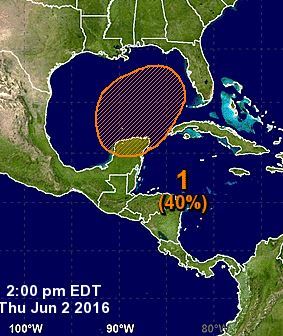
Update 1:53 p.m.: A disturbance brewing in the Caribbean Sea has been given a 40 percent chance of development over the next five days by the National Hurricane Center.
Check The Palm Beach Post radar map.
Forecasters believe an area of low pressure will form over the Yucatan Peninsula or in the southern Gulf of Mexico by late this weekend with strengthening occurring as it moves north-northeastward across the Gulf of Mexico.
If it gathers enough strength from the 80-plus degree waters in its path to become a tropical storm, it would be named Colin.
But whether it earns a name or not, Florida is expected to get a dousing.
“What is important is the potential flooding and high chances of rain that will be more widespread over Central and South Florida,” said Brad Diehl, a meteorologist with the National Weather Service in Miami. “That’s the main message we are trying to drive home here.”
The system could hit between Tampa and Fort Myers by Tuesday.
Previous story: The National Hurricane Center has increased the chances of a tropical system developing over the next five days to 30 percent.
Forecasters expect an area of low pressure to form over the southern Gulf of Mexico by early next week with slow development as it heads north northeast.
While the National Hurricane Center is not defining areas vulnerable to the possible system yet, AccuWeather has pointed to Florida, western Cuba and southeastern Mexico as regions that should keep an eye on the disturbance.
If this system gathers enough steam to reach tropical-storm force, it would be named Colin.
“Provided winds aloft remain light over the region, a slow spin could take shape with the showers and thunderstorms as they develop and drift northward toward the southeastern Gulf of Mexico,” AccuWeather noted in its forecast this morning.
Forecast models consistently show this possible system hitting Florida on Tuesday.
Weather Underground meteorologists Jeff Masters and Bob Henson said the Florida Keys will likely get two to four inches of rain regardless of whether a tropical depression forms.
Source: http://weatherplus.blog.palmbeachpost.com